
Most Scenic Bike Trails in Southern Ontario
Southern Ontario is a haven for outdoor enthusiasts, offering a diverse range of landscapes that are perfect for cycling adventures as well as daily bike cruise. From charming city trails to breathtaking routes through Muskoka and the iconic Algonquin Park, this region boasts some of the most scenic bike trails in Canada. Whether you’re a seasoned cyclist or a casual rider, these trails promise unforgettable experiences amid nature’s beauty. Let’s embark on a journey to discover the best and most picturesque bike trails in Southern Ontario. It is not easy to pick the top ten bike trails in Ontario because there are so many beautiful ones, yet these are the best rated and easy accessible ones.

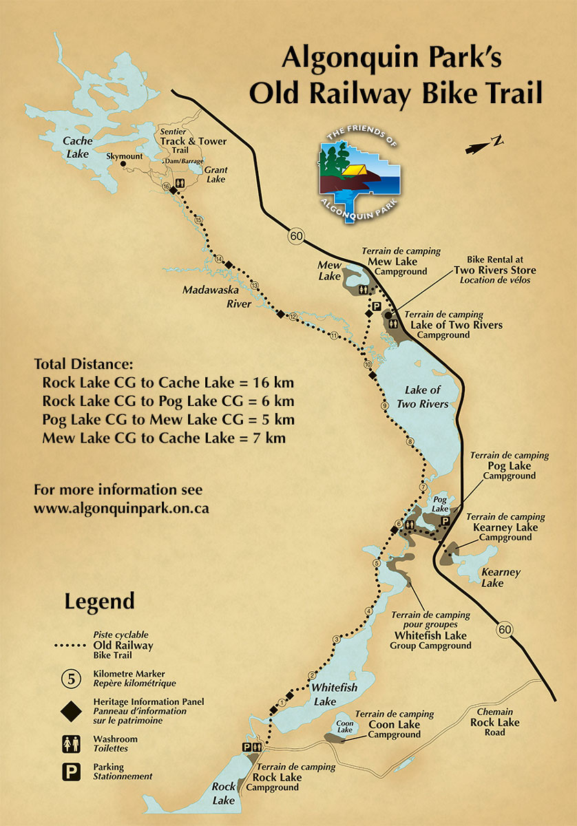
Algonquin Park Old Railway
It is hard to wright about bike trails and not including Ontario wilderness gem. Algonquin Park, which is home to a wide variety of animals, lakes and streams, and beautiful, lush forest, essentially gives you a taste of everything that’s excellent about Ontario. And by far, riding a bike back down the Old Algonquin Railway Trail is one of the best ways to discover it.
You can also rent a bike from Algonquin Outfitters near the Lake of Two Rivers Store, Cafe, & Grill at the trail’s beginning to have an affordable, authentic, and up-close-and-personal Park experience. The Algonquin Park Bicycle Trail is a dream come true for nature enthusiasts. This trail introduces cyclists to the untamed beauty of Algonquin Park, renowned for its pristine lakes, dense forests, and abundant wildlife. As you pedal through this wilderness paradise, keep an eye out for moose, deer, and other creatures that call the park home. The trail offers an unforgettable opportunity to connect with nature in its purest form.
It’s difficult to picture the loud chugging of a railway slicing through the trees on this trail since it’s so peaceful. However, for the majority of its 32 kilometres, the Old Algonquin Railway Trail travels along the disused path of the once-famous Ottawa, Arnprior, and Parry Sound Railway, which began operations in 1896 and ceased operations in 1959.
Therefore, even in rainy conditions, cyclists can travel over the wide, flat trail from Rock Lake to Cache Lake. Additionally, this track is excellent for families and those with little to no bike experience because the terrain is not harsh. Although the trail is mostly flat, be aware that it is a little uneven at first. But once you reach the area where train tracks originally were installed, those modest steep areas quickly come to an end.

For details on length and location of this beautiful bike trail visit Algonquin Park Website.
READ MORE: What is Up with Leaves Falling Already in August?
Torrance Barrens Trail
Torrance Barrens Bike Trail is located in the heart of Muskoka, a paradise for boaters, cottage owners, water sport wizards and nature lovers. Torrance Barrens Bike Trails sits on the first permanent Dark Sky Reserve in the world, the Barrens’ bedrock and wetlands are home to 4,700 acres of superb riding (and hiking) routes. In fact, the location offers 3 clearly marked paths with a combined length of more than 15 kilometres for public usage.
Additionally, the Barrens is well-known among stargazers for its breathtaking, light pollution-free 360-degree vista of the night sky. Bring your bike, and stay for the stars. 14 km of easy to moderate paths constructed of hard packed dirt, granite, and wooden boardwalks are available at the Torrance Barrens Conservation and Dark Sky Reserve. The trailhead is conveniently located off Highway 169 in Torrance; simply drive onto Southwood Rd, travel along it for about 8 kilometres, then bear left at the fork in the road and adhere to the given signage. On the left side of the road, there is parking. Unlike other trails in the area, the Torrance Barrens offers riding conditions that are different from those seen elsewhere. It is reasonably flat and smooth, making it ideal for family rides.
From Bala or Gravenhurst, travel north on Muskoka Road 169.
Southwood Road (Muskoka Road 13) is turned south; it is 7 miles to the Torrance Barrens sign. Simply park on the flat rock.
Stone cairns, white marks painted on rocks, and metal signs serve as trail markers.
For more information on Torrance Barrens Trail please visit Ontario Park Trails Map
Bruce Peninsula Trails
Venturing slightly west, the Bruce Peninsula Trails offer a unique biking experience amid dramatic landscapes. Explore rugged coastlines, limestone cliffs, and turquoise waters as you navigate the area’s various trails. Don’t miss the opportunity to visit Bruce Peninsula National Park and witness the awe-inspiring Flowerpot Island formations. Cycling on the Bruce Peninsula can be done on the road, for fun, or on a mountain bike. Numerous hardtop routes covering hundreds of kilometres allow for superb road cycling through picturesque countryside with just the right amount of turns, climbs, and curves to keep things interesting. On the mountain bike trails, which feature challenging ascents and exhilarating descents, it’s simple to get down and dirty. Community and rail trails crisscross the area, traversing through wooded regions, along shorelines, and across open fields for a more leisurely cycling pace.
From Bruce Peninsula Mountain Bike Adventure Park, Brant Tract Trail, Carrick Tract, Lindsay Tract to speed cycling loops, Bruce Peninsula will make every cyclist heart beat a little faster.

READ MORE: Algonquin Park: A Must Visit Destination for Nature Lovers
Prince Edward County Trails
Known for its rolling hills, vineyards, and charming small towns, Prince Edward County is a cycling paradise. Explore scenic backroads, enjoy the tranquility of the countryside, and discover hidden gems as you pedal through this picturesque region. The county’s relaxed pace and inviting atmosphere make it a perfect destination for a leisurely bike ride.
There is total of 8 trails in Prince Edward County:
- The Cressy Loop.
- The South Shore.
- Park Route.
- Western Wine Route.
- Lakeside Route.
- Big Island Route.
- The Green Point Route.
- The Millennium Bike Trail.
Most bikers have the goal of riding all 8 trails. If it isn’t already on your bucket list, go ahead and add it than all of those trails are worth every second of your time.
A 60 km loop known as the Cressy Loop extends from Picton around Picton Bay all the way to the Glenora Ferry. When you reach the summit of the hill on your bicycle, pause briefly to admire the breathtaking view of the Adolphus Reach. Visit Schoolhouse 77 for light refreshments and the free use of their tire pump, or stop for a meal at The Miller House at Lake on the Mountain Resort. Above the Reach, Cressy Loop continues until it enters Picton again.
You travel to Point Traverse on County Road 13 through the South Shore. This trail is long and rewarding for bicycling. Every cyclist’s dream location, the landscape is unmatched. Beyond the magnificent cliffs and the breathtaking view of Lake Ontario, entering the Little Bluff Conservation area will give you a fresh appreciation for the natural world. You should also keep an eye out for the Prince Edward Point Bird Observatory, Half Moon Bay Winery, and a few galleries.
There are other benefits to biking this 65 km Park Route in addition to the satisfying sense of accomplishment. You visit The Sandbanks Provincial Park, take in the grandeur of East Lake, and take in the breathtaking scenery. To replenish on the best cheese, don’t forget to go to Black River Cheese. Along this journey, you’ll also see many of sugar maples, asparagus, and lilacs.
This is the path you should start out on if you’re a new cyclist. The topography on this 40-kilometer track is the easiest of all the biking trails in Prince Edward County. You’ll pass by some well-known wineries in the County if you travel counterclockwise along the Western Wine Route, including Keint-He, Sandbanks Winery, Rosehall Run, Casa Dea, Domaine Darius, and Sugarbush. Take a quick break for breakfast at The Saylor House Cafe or the Bloomfield Public House. On your walk back to Bloomfield, take in the wonderful views of the West Lake shoreline and the sand dunes.
For more information on Prince Edward County Bike Trails Visit My Prince Edward County Website.

Niagara River Recreation Trail
Experience the charm of Niagara-on-the-Lake and the awe-inspiring Niagara Falls on the Niagara River Recreation Trail. Following the Niagara River, this trail treats cyclists to mesmerizing water vistas, vineyards, and historic sites. The gentle terrain makes it suitable for riders of varying skill levels, and the trail’s proximity to world-renowned wineries adds a touch of sophistication to the journey.
By pausing to read and examine the signs and memorials along the road, the scenic drive is not only lovely but amusing and educational as well.
Start at the Old Fort Erie parking lot in Fort Erie’s southern section by taking the Peace Bridge from Interstate 190 in Buffalo, New York, then turning onto Queen Elizabeth Way in Canada. As you approach Route 124 (Central Ave), make your first right. Turn right at Lakeshore Rd after continuing. The road temporarily divides. Keeping going straight, pass Old Fort Erie on your right as you travel Lakeshore Road. On your left, there will be a parking area and the trail’s beginning.
Starting at the Nelson Street parking lot in Niagara-on-the-Lake, head north along Route 405 across the Lewiston-Queenston Bridge from I-190 in Lewiston, New York. To reach Route 61, take the first exit in the direction of Niagara-on-the-Lake. After turning right, take Route 61 until it ends at Niagara River Pkwy. To reach a 3-way intersection, turn left and go 6.5 miles (10.5 km) north. After crossing the parking area for the Niagara River Recreational Trail, turn right onto Ricardo Street. As you enter Niagara-on-the-Lake on Ricardo St, Nelson St will be on your right just before a marina.
The regional Greater Niagara Circle Route includes the Niagara River Recreational Trail. Between Thorold and Niagara Falls, [the Bridge-It Route goes on roads, slicing the Circle Route in half. [SEE: Cycling directions from Chippawa, Ontario’s Port Robinson’s Ferry parking lot to the Niagara Parkway. Along both the Great Lakes, the Niagara River, and the Welland Canal, four interconnected pathways unite to form a circuit that runs north-south and east-west. This trail joins the Friendship Trail, which runs east-west between Fort Erie and Port Colborne, at its southernmost point. This trail joins the Waterfront Trail, Lake Ontario/Niagara Section, which runs east-west between Niagara-on-the-Lake and St. Catharines, at its northernmost point.
Finally, the Welland Canal Trail, which runs north-south between Port Colborne and St. Catharines, connects the Waterfront Trail and Friendship Trail.

READ MORE: Best Boating Places in Ontario
Southern Ontario is definitely “Yours to Discover” as there are so many great bike and hike trails to be discovered. Above listed trails are just few great options for you to ride on. What is your favourite one?


[RESULT-START]
Wow, this blog post has me itching to go on some biking adventures in Southern Ontario! The Algonquin Park Old Railway Trail sounds absolutely amazing, I can’t wait to explore the untamed beauty of the park while riding my bike. I also love that the Torrance Barrens Trail offers a unique stargazing experience, it’s like two adventures in one! My question for the author is: Have you personally biked all of these trails in Southern Ontario? If so, which one is your absolute favorite and why? Can’t wait to hear your thoughts!
[RESULT-END]